
March 31, 2021, 2:00 pm | Read time: 4 minutes
Google Maps is the world’s most popular online mapping service. Users can access maps, set routes, and receive route information on both desktop and smartphone. Google Maps has announced new features for the app in the coming weeks.
A key focus is the environment. In the future, users will have the option to choose routes that are particularly climate-friendly. According to the company, this is possible thanks to advances in artificial intelligence.
New Google Maps Features Aim to Help the Environment
When planning a route with Google Maps, users can choose the path that causes the least CO₂ emissions. This option will also be selected by default if the travel time does not significantly differ from the fastest route. A.I. calculates the CO₂ impact of each route based on data such as route layout, elevation, and traffic. Initially, this new feature will be available in the U.S., but a global rollout is definitely planned.
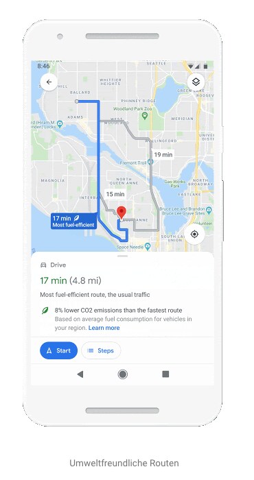
Additionally, a new route view will suggest more environmentally friendly alternatives while on the go, without significantly extending travel time. The A.I. will automatically suggest the user’s preferred modes of transportation, such as bicycles. This aims to encourage more frequent use of eco-friendly transportation. According to Google, the infrastructure of the respective area will also be considered.
Starting in June 2021, a new feature will be available in Germany that alerts users to environmental zones. In these zones, specific emission regulations apply to vehicles. A notification will pop up on the smartphone, possibly suggesting an alternative route.

Google Maps Expands Offerings for Cyclists

Ten Little-Known Features of Google Maps and Apple Maps
New Feature Brings Indoor Live View to Google Maps
Last year, Google Maps introduced the Live View feature for pedestrians. Live View uses augmented reality to match what you see with your smartphone camera to Street View imagery. This allows Google Maps to determine the exact position and orientation. You simply look at your smartphone screen, where directional markers are overlaid on the Street View image.
Until now, Live View was only available outdoors. According to a blog post from Google: “Thanks to new developments that help us determine the exact height and placement of objects within a building.” Google Maps can now recognize which floor you are on, enabling navigation within buildings that have Street View material. This includes airports, train stations, and shopping centers.
You can now be guided to check-in, gates, baggage claim, as well as platforms and ticket machines. Directions for elevators, restrooms, and ATMs are also available. For now, Live View for indoor spaces is only available in select cities in the U.S., as well as Tokyo and Zurich. More cities are expected to follow.
Display of Weather and Air Quality and Many More Features
Google Maps is also getting new map details that can provide even more information about the destination. These include options for air quality and weather. When searching for a location with the weather setting, Maps shows the current temperature and weather conditions. Additionally, an hourly forecast appears in a box.
With the air quality setting, you get more information about the pollution level at the destination. A scale also shows how healthy or unhealthy the air is and whether it is suitable for outdoor activities. Air quality is useful for people with allergies and provides insight into whether the destination is in a wildfire-prone area. According to Google Maps, they work with the Weather Company and the Central Pollution Board, among others.

Overall, more than 100 new improvements are planned for Google Maps, all primarily relying on advanced A.I. technology. Among other things, an Assistant Driving Mode will soon be available in Germany, integrating messenger messages into the app, which users can have read aloud. We will keep you updated on further developments.